In May 2009 I finally got around to completing a trip I’d been planning for about twenty years, namely to cycle through the Outer Hebrides islands of Scotland, from Barra in the South to Lewis in the North. Of course, I took a camera with me and since every ounce of weight had to carried I wanted to keep the weight down.
My camera equipment choice was:
- One 35mm SLR – the very light Canon EOS300 which I have previously blogged about
- Canon 50mm/f1.8 standard lens
- Sigma 24mm wide-angle
- Gorillapod SLR mini-tripod.
- Cokin 2-stop and 3-stop graduated neutral density filters and holder
- Bellows-type lens hood
- 3 rolls of Fuji Velvia 50 1 roll of Fuji Sensia 400 slide film
4 rolls of film would give 144 shots – which some people would use up in an hour of digital shooting, but it did last me throughout the eight day trip, and in fact I didn’t finish the last film – I think I took about 120 images in total.

The only item I wish I had left behind – although it didn’t weigh much so this doesn’t really matter – was the gorillapod. I only used it once, because it can only really raise the camera a few inches off the ground, unless you are lucky enough to find a table, fence, or flat rock, in the exact position which gives you the composition you really want. I’ve since sold it.
I didn’t use a camera-specific bag; since I would have a variety of soft items like clothes inside my Altura panniers (which turned out to be completely waterproof, as proved when I cycled 10 hours in the rain), I just wrapped the camera equipment inside clothing, or a bit of bubble wrap, inside the panniers. This worked well enough except for the filters, one of which broke when packed.
I didn’t fancy cycling all the way from Newcastle to Barra, so the first day was occupied by three trains; Newcastle to Edinburgh; Edinburgh to Glasgow; and Glasgow to Oban, followed by the ferry journey from Oban to Barra.
The first full day on the Hebrides was a very rainy one … not very unusual for that part of the world. Barra is joined by causeway to Vatersay, which is the southernmost occupied island in the Outer Hebrides archipelago. So I started off my trip northwards by actuallly going south, to take in a circular tour around Vatersay and Barra, in the rain and wind.


The light levels weren’t ideal for ISO50 film ….
On to Eriskay and the Uists
The following day I caught a ferry to Eriskay, which is linked by a series of causeways to South Uist, Benbecula, North Uist, and Berneray.
The weather for the first hour was a slight improvement on the previous day.


Unfortunately, by the time I crossed to South Uist, the rain started again. The best approach was just to keep on cycling because I got colder when I stopped. I had planned to stay at the Gatliff Trust hostel at Howmore, but because I wasn’t stopping for sightseeing, I would have arrived by 1.00pm and decided to press on instead to Berneray Hostel – which mean that I cycled 82 miles, mostly in the rain, through Benbecula and North Uist.
I also made the mistake of being too fussy when searching for food in the sparsely-stocked shop at Lochmaddy, coming away empty-handed, and finally arriving on Berneray when any shops there were shut. So I arrived at the excellent hostel at Berneray, in a gale, with just some porridge to eat. Fortunately some fellow-hostellers spared me a cheese sandwich so I didn’t starve.


By the next day, the rain had gone and stayed away for the rest of the trip, but the strong winds stayed with me.
After a walk around Beneray, I got the ferry to Harris. Now … this was Sunday; and Sunday on Harris means everything is shut, and the opportunities for shopping and eating are extremely limited. Fortunately the Butty Bus near the harbour in Leverburgh was able to supply a bacon sandwich – just as well as I couldn’t find anything else to eat until I arrived that evening in Tarbert, the capital city town village of Harris.
Harris turned out to be the best part of the trip – the scenery and photographic opportunities are fantastic, so much so that I returned in 2011, travelling by car so that I could carry the Mamiya RZ67 (and a few other cameras) and explored Harris and Lewis in more detail. (I have some articles from that trip here, here, here, and here.


This was the only occasion on which I was able to photograph a sunset on this trip. I should explain that cycling is generally speaking a great companion to photography, because you can spot suitable locations more thoroughly than you can when motoring, and don’t have the problem of finding somewhere to park the car then walking back to the image location. But when cycling past great spots like Luskentrye with good sunset potential, I was frustrated by the knowledge that I had many miles to go (uphill, and with little food in the panniers) to my evening stay, and I didn’t fancy staying at the beach until sunset then completing the journey in the dark.
With the image above, I was staying in Tarbert when I could see the sunset starting to develop, so I grabbed the bike and cycled the short distance to Pier Road where West Loch Tarbert presented some suitable water for the sun to set over. The waterfall seems to be a temporary affair, because when I passed the spot two years later, there was no sign of it.


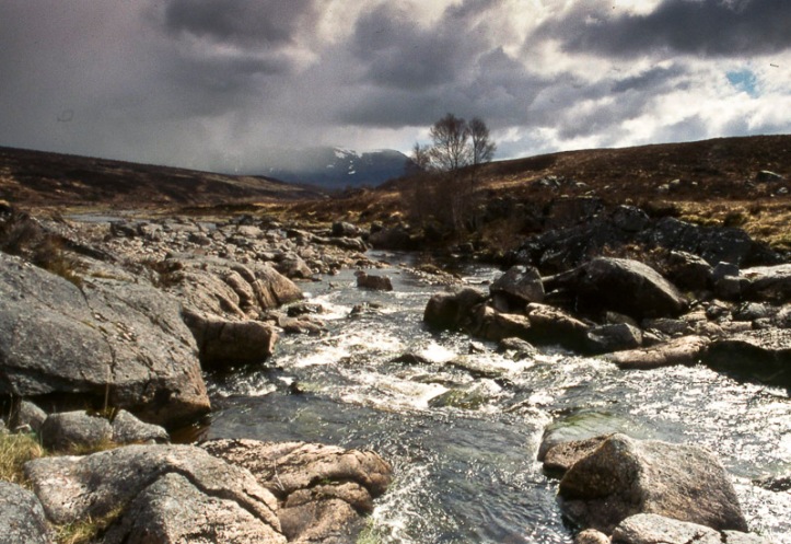
From Rhenigidale I cycled north and west to Lewis – although the names “Isle of Lewis ” and “Isle of Harris” exist, they are actually parts of the same land mass. As you move further on to Lewis, the interior becomes less hilly and more boggy and the photographic interest points are concentrated around the coast.


I stayed at Gerranan Blackhouse Village, in what was at that time a Gatliff Trust hostel; but the lease has reverted back to the to village owners who run the blackhouse museum, who I think have refursbished the hostel building and re-opened it (the foreground building in the image above).

After a side-trip to Dalbeg – or it might have been the adjacent beach of Dal Mor – I cycled east to Stornoway over the “Pentland Road”, a narrow strip of tarmac over miles of peat bog. The ferry from Stornoway to Ullapool wasn’t quite the end of my journey, as there is no train line to Ullapool; another 32 miles the next day took me to Garve, the nearest train station on the Kyle of Lochalsh – Inverness line, which provided the first of three trains to take me back home to Newcastle.


Despite the rain for the first two days, it had been an excellent cycling and photography trip. The camera and film choice turned out to be pretty suitable, although if I do something similar in future I would probably take the Fuji GA645Zi.

That’s a great story and an excellent set of images, Kevin. I keep thinking of doing (another) blog of my own, and this is quite inspiring!
LikeLike
A good read, Kevin, and that looks like an excellent trip, some very nice shots too. I’ve thought about doing this precise trip myself on a bike and may very well do so some day; this has helped with convincing me that it’s a good idea 🙂
LikeLike
Beautiful scenery, especially like the touch of sunset.
LikeLike